
What Those Long Streaks on the Water Are Really Telling You
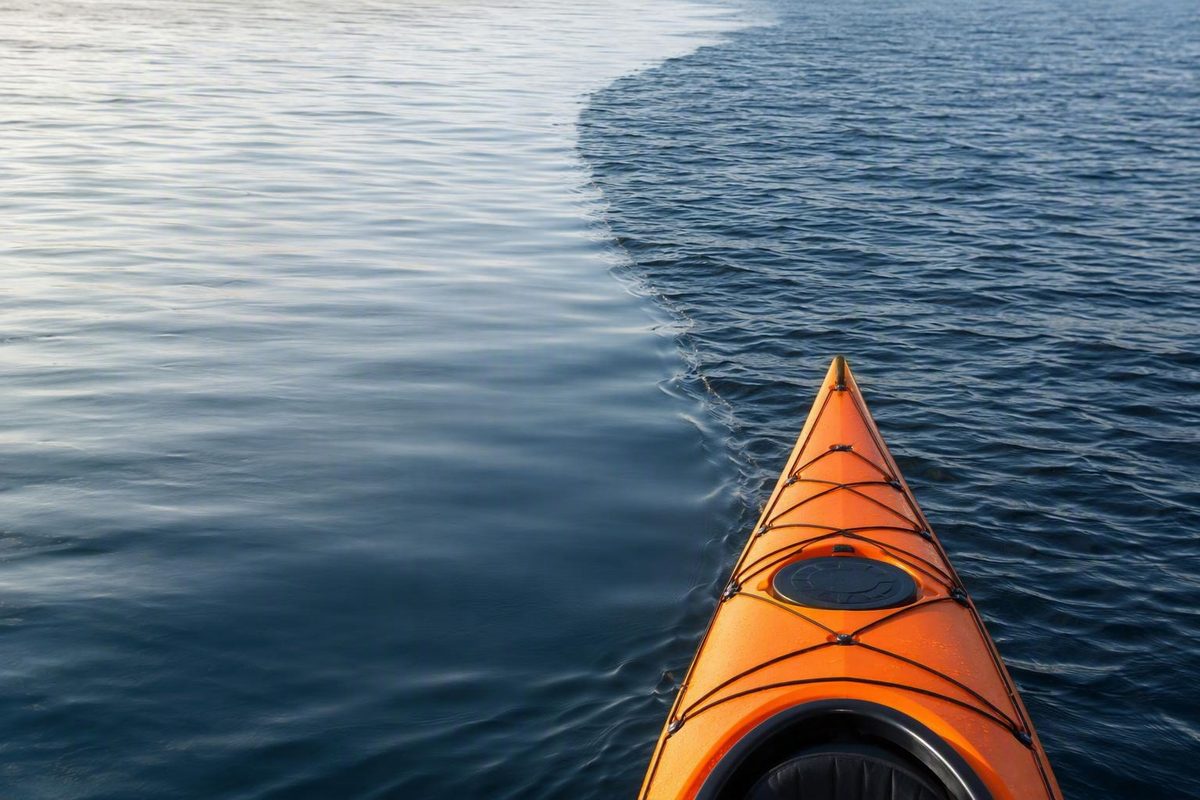
What Is a Wind Lane on Water?
A wind lane is an informal, context-dependent name for a visible streak or boundary associated with wind acting on water. It may look smooth, shiny, oily, dark, foamy, or bubble-lined. Sometimes it is simply the sharp line where calm water meets a wind-ruffled surface.
Sailors, anglers, and paddlers do not always mean the same thing by the term. A sailor may be describing long, roughly wind-aligned convergence streaks consistent with Langmuir circulation. An angler may call a calm ribbon among ripples a wind lane or slick; some fishing writers use those terms interchangeably for oily-looking patches (Steve Cullen’s description of wind lanes and slicks).
Paddling and fishing coverage may instead use wind seam for a distinct calm-to-choppy boundary associated with a point of land, weed bed, sheltered area, or adjoining airflow (ReelY’s guide to visible wind seams).
Those descriptions can overlap visually, but they do not establish one common cause.
- Elongated convergence streaks. These may be produced by Langmuir circulation—organized, counter-rotating movements beneath the surface that bring floating material together in long rows.
- Exposure boundaries. These form where one area receives more wind than another because of shelter, fetch, shoreline shape, terrain, buildings, vegetation, or interacting local airflows.
The names are descriptions, not diagnoses. A smooth line might be a wind-related convergence, but it might also reflect shelter, current, a wake, a surface film, or changing light.
Short answer
Wind lanes often extend roughly with the prevailing wind and may collect bubbles, foam, weeds, insects, or debris. Some are consistent with Langmuir circulation; others mark differences in wind exposure. They are clues—not exact indicators of wind direction, speed, an approaching gust, or safe conditions.
The most reliable way to interpret one is to use four steps:
- Observe its texture, shape, movement, and contents.
- Infer one or more plausible causes.
- Cross-check against ripples, geography, wind indicators, current, weather, and instruments.
- Reassess as your position, viewing angle, or conditions change.
What Wind Lanes Look Like From Shore or a Boat
Wind lanes do not have one dependable color or texture. The same physical streak may look bright from one direction and dark from another, especially when the sun is low or the observer is close to water level.
Common appearances include:
- a smooth or oily ribbon cutting through fine ripples;
- a shiny, glassy streak between darker textured bands;
- a darker or rougher strip within smoother water;
- a line of bubbles or foam;
- a row containing leaves, weed fragments, insects, or other floating material;
- several nearly parallel lines extending across open water;
- a sharp boundary between calm and choppy water;
- a wandering or branching line rather than a perfectly straight stripe.
A convergence streak may begin as a subtle calm line and become more conspicuous as bubbles, foam, or debris accumulate. In one documented lake observation, calm streaks later became bubble- and foam-lined as the wind increased. That example illustrates how a lane can evolve rather than retain one fixed appearance.
Read texture before color
Dark water does not automatically mean stronger wind. Cloud shadows, glare, sun angle, water color, and viewing direction can all change apparent brightness. A dark patch becomes a more useful wind clue when it also shows a physical change such as:
- newly formed fine ripples;
- visibly coarser texture;
- an advancing disturbance;
- small breaking crests;
- sparkles corresponding to roughness rather than glare alone.
A bright patch can still be windy if reflected light conceals its texture. Conversely, a dark area without a physical change in the surface may be only a shadow.
Fine texture and larger waves also tell different stories. Small, newly forming ripples can be more representative of present surface forcing, while larger waves may have traveled from elsewhere or persisted after the local wind changed. SailZing’s instructional synthesis recommends distinguishing current wind texture from the underlying wave field (SailZing’s guide to seeing wind on the water).
Because brightness depends on viewing geometry, examine the same feature from more than one position when practical. Concentrate on whether the surface itself is smoother, rougher, converging, or moving—not merely whether it looks light or dark.
| Label | Typical appearance | Plausible cause | Useful clue | Main limitation |
|---|---|---|---|---|
| Wind lane | Long smooth, shiny, dark, foamy, or bubble-lined streak | Langmuir convergence or another wind-related pattern | Often extends roughly with prevailing wind | Informal label with several meanings |
| Langmuir streak | One of several elongated, roughly parallel rows | Surface convergence above counter-rotating circulation cells | Bubbles or debris may collect along the line | Subsurface circulation cannot be confirmed from appearance alone |
| Slick | Calm or oily-looking patch among ripples | Convergence, surface film, or locally smoother water | Distinct reduction in small-wave texture | “Slick” describes appearance, not mechanism |
| Wind seam | Sharp calm-to-choppy boundary | Shelter, different exposure, vegetation, terrain, or adjoining airflow | Often relates to a shoreline or surface feature | May resemble current or other boundaries |
| Gust patch | Moving area of newly roughened water | A puff producing fresh surface texture | Advances and changes rather than remaining fixed | A cloud shadow can mimic its color |
| Foam or bubble row | White, pale, or beaded line | Floating material gathered by convergence or another flow | Visible material indicates collection or transport | Does not prove a wind-driven cause |
How Langmuir Circulation Can Create Parallel Streaks
One important mechanism behind wind lanes is Langmuir circulation. In accessible terms, the upper water organizes into adjacent, elongated rolls running approximately with the wind. Neighboring rolls rotate in opposite directions.
Where the surface motions of two adjoining rolls meet, they bring water toward the same line. This is called surface convergence. Some of the converging water then moves downward.
Bubbles, foam, leaves, weed fragments, and other floating objects may therefore accumulate above the convergence. Seen from shore or overhead, those collected materials can make the circulation visible as a long row.
A sailing synthesis of wave-pool research also reports that surface-wave height can be reduced where water sinks, helping explain why a convergence line may appear smoother or shinier than its surroundings. It describes counter-rotating water “tubes,” surface flow toward the line between them, and downward movement beneath the visible streak (SailZing’s explanation of wind lanes and Langmuir circulation).
In cross-section, the basic pattern is:
- two adjacent cells rotate in opposite directions;
- surface water moves toward the boundary between them;
- water descends beneath that boundary;
- floating material remains near the surface and collects in a row.
From overhead, several such rows may appear as approximately parallel lanes extending with the prevailing wind.
This is a useful mechanism, but it is not a visual test. The cited account is a sailing article interpreting a fluid-mechanics study rather than the primary study itself. It supports Langmuir circulation as a plausible explanation for organized, wind-aligned streaks; it does not justify identifying every smooth or debris-filled line as a Langmuir lane.
Real patterns are also less orderly than simplified diagrams. Lanes may wander, merge, intersect, fade, or become distorted by waves, turbulence, temperature differences, current, and changing wind. Shoreline terrain can shape the airflow reaching the water, but it does not explain every line on a lake.
Do Wind Lanes Show Wind Direction?
As a practical rule:
- organized Langmuir streaks tend to extend roughly parallel to the prevailing wind;
- the crests of fine wind ripples generally lie across, or roughly perpendicular to, the wind.
This resolves a common source of confusion. The long lane and each small ripple crest can have different orientations because they are different surface structures.
SailZing’s wind-reading guidance also suggests that the inner side of a curved fine ripple can provide a clue to the windward direction. Treat that as one observation to compare with other indicators, not as an exact compass bearing.
Wind lanes can suggest prevailing or recent wind, but not with absolute accuracy. One sailing account reports that organized rows may differ from the wind direction by as much as about 20 degrees. The same account says initial organization may take roughly 20 seconds or more, after which rows can decay slowly when the wind changes. These are attributed observations rather than universal limits.
The practical lesson is that a lane can lag behind a shift. It may preserve the direction of recent wind even while a new puff is arriving from somewhere else.
For an approaching gust, watch for a patch that is both moving and genuinely becoming rougher. Do not rely on darkness alone. Track the area’s leading edge and compare it with several independent clues:
- flags or pennants;
- smoke;
- exposed vegetation;
- sheltered and unsheltered shorelines;
- nearby sails or boats;
- a forecast or wind instrument.
Obstacles complicate the picture. Buildings, steep banks, trees, and points of land can shelter or redirect local airflow. Mitch Mitchell’s kayak-instruction article notes that even a nearby flag may mislead when it is in disturbed air behind an obstacle (Coastal Kayak’s guide to visual wind clues).
Myth versus reality
Myth: Wind lanes point exactly into the wind. Reality: Organized lanes often run approximately with prevailing wind, but they can curve, deviate, persist after a shift, or reflect locally redirected airflow.
Myth: A wind lane predicts the next gust. Reality: Persistent lanes take time to organize and fade. A moving area of newly roughened water is generally a more relevant gust clue.
Myth: Darker water always means more wind. Reality: Darkness is useful only when it corresponds to genuine surface texture. Shadows and viewing angle can change color without changing wind.
Why Lanes Form, Change, or Disappear
Visible wind lanes depend on more than wind speed. Their clarity can be affected by:
- wind strength and steadiness;
- fetch;
- the existing wave state;
- turbulence;
- water and air temperature;
- recent wind history;
- surface tension and films;
- shoreline shape;
- vegetation, buildings, and terrain;
- current and other local water movement;
- viewing angle and light.
Fetch is the distance over which wind acts on the water. Along a sheltered upwind edge, the wind may have little room to build ripples and waves. Farther downwind, the same airflow has acted over a longer stretch, allowing more texture to develop.
A glassy near shore and rougher water farther out may therefore reflect exposure and fetch rather than a narrow convergence lane.
Points, coves, steep shorelines, buildings, and vegetation can divide the surface into zones receiving different amounts or directions of wind. A sharp line beginning beside one of these features may be a sheltered wind seam: calm water on one side and ruffled water on the other. That differs conceptually from a set of parallel open-water convergence rows, although both patterns can occur in the same scene.
Relatively steady wind gives organized rows time to develop. Rapid shifts, crossing waves, increasing turbulence, and temperature differences may bend, break up, or obscure them. A lane can also remain visible after the forcing changes if foam or debris has already collected.
Approximate wind-to-water progression
The following speed ranges and appearances come from an instructional synthesis of visual wind guidance. They are approximate observations—not exact measurements, formation thresholds, operating limits, or safety criteria (SailZing’s wind-strength indicators).
| Approximate wind speed | Possible water appearance |
|---|---|
| 4–7 mph | Small, generally nonbreaking waves |
| 8–12 mph | Larger waves, first breaking crests, and possible streak formation |
| 13–18 mph | Longer waves and frequent whitecaps |
| 19–24 mph | More pronounced waves and many whitecaps |
That synthesis places noticeable streak formation in the 8–12 mph range. A separate sailing account reports observing lanes at approximately 6–7 mph. The figures should not be averaged into one supposedly exact threshold.
The difference is unsurprising. Observers may use wind lane for different features, while wind steadiness, fetch, temperature, existing waves, surface conditions, and viewing angle all affect what becomes visible.
Wind may also be present without obvious ripples. Local shelter or surface conditions may limit visible small-wave development, while glare and viewing geometry may conceal texture that is present. The absence of a visible lane is not proof that the water is calm.
Wind Lane or Lookalike? A Field Identification Checklist
The available evidence does not support conclusive identification from appearance alone. Use the following checklist to improve an interpretation, not to prove it.
1. Observe before naming the feature
Record what is physically present:
- smooth, rough, shiny, dark, or foamy water;
- bubbles or floating material;
- a straight, curved, branching, or parallel pattern;
- a stationary, slowly evolving, or rapidly advancing line;
- an isolated feature in open water or one connected to shore;
- calm water, ripples, waves, or visible flow on either side.
A neutral description helps prevent every line from being forced into the same category.
2. Check alignment
Compare the feature’s long axis with fine ripple crests and an independent wind clue. If several lanes extend approximately with the wind while ripple crests run across them, Langmuir circulation becomes a plausible interpretation.
But a feature that repeatedly crosses the apparent wind calls for alternative explanations.
3. Inspect what the line contains
Bubbles, foam, insects, weeds, leaves, or debris support the possibility that floating material is being brought together. They do not establish whether wind-driven convergence, current, shoreline circulation, a wake, or another process created the line.
If you can observe safely from a stable position, note whether material appears to collect along the line, travel along it, or simply remain scattered within it. Treat the result as another clue rather than a definitive test.
4. Inspect the geography
A boundary beginning near a point, weed bed, steep shore, building, marina structure, or sheltered cove may reflect different wind exposure. Ask whether the pattern repeats in open water or occurs only beside the obstruction.
Also consider fetch. A broad increase in texture farther downwind is more consistent with changing exposure than with one narrow lane.
5. Consider current
V-shaped disturbances, swirls, eddies, and flow-related smooth patches may suggest current-related movement. That appearance is not conclusive: wind can overlay or distort a current pattern, and both mechanisms may operate together.
Avoid treating a single photograph or momentary view as proof of current direction or strength.
6. Rule out optical effects
Compare color with actual texture. Does the dark area contain more ripples, breaking crests, or moving surface disturbance, or is it only a change in tone? Does it move across the scene with a cloud shadow?
Changing your viewing position may reveal whether glare created the apparent boundary. Even then, subtle texture can be difficult to distinguish, especially from a low angle.
7. Consider time
A persistent or slowly evolving row may reflect prevailing or recent wind. A newly arriving puff is more likely to appear as an advancing patch of fresh roughness.
Time helps form an interpretation; it does not guarantee one.
8. Cross-check and reassess
Compare your interpretation with:
- flags, smoke, trees, reeds, or grasses;
- nearby boats and sails;
- the forecast;
- onboard wind instruments;
- changes observed as you move around a point or out of a cove.
| Feature | Pattern that may support the interpretation | Most useful cross-check | Important limitation |
|---|---|---|---|
| Probable Langmuir streak | Several long, roughly parallel rows; smoothness, bubbles, foam, or debris | Alignment with prevailing wind and crosswind ripple crests | Appearance cannot confirm subsurface circulation |
| Sheltered wind seam | Sharp calm-to-ruffled boundary tied to a point, cove, vegetation, or structure | Compare exposure and fetch on both sides | Current or a surface film may look similar |
| Gust patch | Advancing area with genuinely new, coarser texture | Track movement and compare independent wind indicators | Cloud shadow can mimic its color |
| Current disturbance | V-shape, swirl, eddy, or flow-related smooth patch | Compare the pattern with other signs of water movement | Wind can overlay or distort it |
| Wake | Diverging or curved wave pattern associated with a vessel or probable track | Observe how the pattern changes over time | Old or intersecting wakes can become ambiguous |
| Optical shadow | Dark or bright area without corresponding texture | Watch cloud movement and change viewing angle | Subtle texture may still be difficult to see |
The supplied evidence does not provide a definitive visual test for separating every wake, weed edge, algal patch, oil film, depth change, or current line. If the cause matters for navigation or environmental reporting, do not identify it solely by resemblance to a photograph.
What Wind Lanes Mean for Paddlers, Sailors, and Small Boats
Surface patterns are most useful when treated as one layer of situational awareness rather than a complete reading of conditions.
For sailors
Fine texture can help identify water affected by present wind, and a moving area of roughness may reveal a puff. Longstanding lanes may lag behind a shift, however. Use them to estimate prevailing or recent direction, then compare them with the sail, telltales, other boats, and broader movement of rough water.
For paddlers
A lane can help compare shelter and exposure. Smooth water behind a point and rough water beyond it may show the edge of local protection. Fetch may also explain why conditions become more textured farther from the upwind shore.
Neither observation determines whether a crossing or return trip is safe.
For small-boat operators
Separate fine present texture from larger residual waves. A boat may encounter waves generated by earlier or more distant wind while the current local wind comes from another direction. Look for the smallest new ripples superimposed on the larger wave field.
Terrain and structures complicate the reading. One flag, one patch of water, or one shoreline observation can therefore be misleading.
A conservative routine is:
- Pause long enough to observe movement rather than taking a visual snapshot.
- Separate fine texture, larger waves, persistent streaks, and advancing patches.
- Compare several parts of the water, not only the nearest patch.
- Check the shoreline, terrain, vegetation, and sky.
- Verify with a forecast, wind instrument, flag, smoke trail, or nearby boat.
- Reassess as the boat changes position and exposure.
Do not infer exact wind speed from a lane or use one streak as the sole basis for launching, crossing open water, choosing a route, or deciding when to return. Wear a properly selected life jacket and use weather information appropriate to the location and trip.
Why Anglers Watch Wind Lanes—and the Limits of the Advice
The fishing interest is straightforward: surface convergence can gather floating material into a narrower band, and angling writers report finding insects and feeding trout in or near visible wind lanes.
That connection is plausible, but the available fishing sources are experiential rather than controlled ecological research. A lane is a reason to investigate—not proof that food or trout are present.
Before casting, look for:
- visible midges, caddis, beetles, ants, or other terrestrial insects;
- foam or natural debris collecting repeatedly;
- rises, bulges, or subsurface flashes;
- cruising fish;
- repeated feeding along a particular section.
Neil Grose reports that food is often—but not always—concentrated along lane edges and recommends adjusting boat position to observed fish (Neil Grose’s experience-based wind-lane tactics). That is a practical starting point, not a universal rule. Check both the center and edges when visible activity does not provide an answer.
From shore
One reported still-water tactic is to take a windward position with the wind behind the angler when access and conditions allow. That can assist downwind presentation, but it is not always the best approach. Shore shape, casting room, glare, fish movement, and crosswind may favor another position.
From a boat
Control is more important than covering the greatest possible distance. Depending on the craft and conditions:
- establish a manageable drift;
- position broadside to the lane where suitable;
- use a drogue only when appropriate for the craft, water, and operator;
- favor shorter, accurate casts;
- cast along the feature or ahead of visibly moving fish.
Derek Aunger’s Fulling Mill article recommends slowing the drift with a drogue, using shorter accurate casts, and presenting along the lane (Fulling Mill’s wind-lane fishing guidance). These are experience-based still-water trout tactics, not universal boat-handling rules.
Match presentation to observed feeding
Use the fish—not the label wind lane—to choose a presentation.
- If fish are visibly taking food from the surface, consider a suitable dry fly.
- If bulges, subsurface flashes, or emerging insects suggest activity just below the film, consider an emerger, wet fly, or nymph.
- If no food or fish are apparent, do not assume a specialized pattern will create an opportunity.
Angling accounts mention midges, caddis, beetles, ants, and other terrestrial insects as possible food. Claims that trout always travel in one direction, remain at a fixed depth, or favor one part of every lane should be treated as local observations rather than rules.
The practical decision is simple: inspect the lane, make a few controlled presentations, adjust to what the food and fish are doing, and move on if the feature shows no evidence of either.
Frequently Asked Questions About Wind Lanes on Water
Do wind lanes run parallel or perpendicular to the wind?
Organized Langmuir streaks generally extend roughly parallel to the prevailing wind. Fine wind-ripple crests generally lie roughly perpendicular to it. Local obstacles, changing wind, waves, and irregular circulation can alter either pattern, so confirm direction with another clue.
At what wind speed do wind lanes begin to appear?
There is no universal threshold. SailZing reports one observation of lanes forming around 6–7 mph, while its broader instructional wind-reading synthesis places noticeable streak formation around 8–12 mph. Different definitions, fetch, temperature, wave state, turbulence, and surface conditions can explain the variation. Treat both ranges as approximate observations, not operating limits.
What is the difference between a wind lane, a slick, and a wind seam?
A wind lane is the broadest informal label and may refer to a convergence streak or another wind-related line. A slick usually describes a smooth or oily-looking patch, especially in angling language. A wind seam commonly means a boundary between calm and wind-ruffled water, often near shelter, vegetation, or a point. The terms overlap, and none identifies the cause by itself.
Do wind lanes always contain insects or feeding trout?
No. Convergence may collect floating insects and debris, and anglers sometimes find feeding trout there. Look for actual insects, rises, cruising fish, or repeated activity before spending substantial time on the feature.
Can wind lanes warn paddlers or sailors that a gust is approaching?
Not reliably by themselves. Organized lanes can take time to form and may persist after the wind changes, so they are better clues to prevailing or recent wind. For an approaching gust, watch for a moving patch that becomes genuinely rougher—not merely darker—and compare it with flags, vegetation, sails, forecasts, or instruments.
Reading Wind Lanes Without Overreading Them
Wind lanes are useful clues, not definitive answers. A long streak may represent Langmuir convergence, sheltered water, changing wind exposure, current, a wake, or an optical effect.
The reliable approach is to examine texture and alignment, look for floating material, account for shoreline and fetch, compare the pattern with fine ripples and independent wind indicators, and keep reassessing. That method can improve wind awareness and help anglers investigate promising water without turning an ambiguous surface feature into a guarantee about wind, fish, or safety.